Pinos Puente offers a visit to the heritage of the Vega de Granada: the Puente de la Virgen, the Consolación church and the works that distribute water. The City Hall locates the urban center to the northwest of Granada, at the foot of the Piorno and Sierra Elvira, crossed by the Cubillas River.
| Plan | Possible stops | What to confirm |
|---|---|---|
| Urban walk. | Puente de la Virgen, Calle Real and church. | Tour according to mobility and opening of the temple. |
| Water heritage. | Crescents and surroundings of Cubillas. | Permitted access and road condition. |
| Information and archeology. | Columbian Route Interpretation Center. | Opening, visit and available content. |
| Exit around the environment. | Municipal water and archeology proposals. | Route, modality and return. |
Bridge of the Virgin or Caliphate Bridge
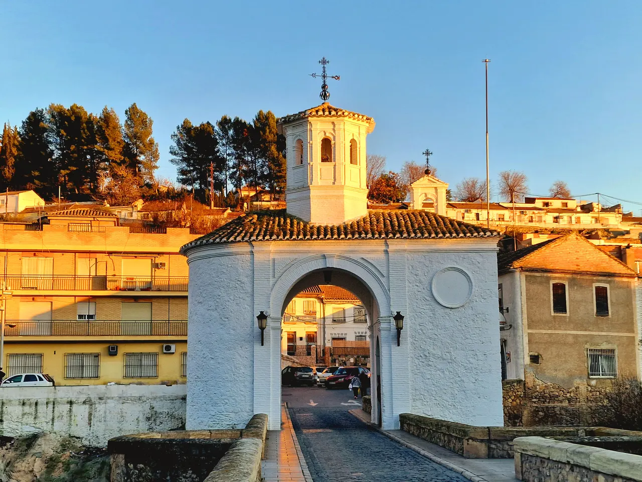
The City Hall portal identifies the Puente de la Virgen over the Cubillas, in addition to the iron bridge and the one on the national highway. It is a reference to begin the walk and locate the two shores.
The municipal tourist information sheet describes three main arches and the chapel of the Virgen de las Angustias, known as “the casica of the Virgin.” He explains that the bridge has undergone reconstructions and transformations over the centuries. During the walk, observe how the chapel is integrated into the passage between the two banks.
Observe the complex from permitted points, respecting traffic and local indications. If you want to enter the chapel, check its opening. For photographs, look for a safe position without going into the riverbed or invading a road.
Consolación Church and walk along Real Street
The same source of heritage identifies the church of La Consolación: three naves, stone pillars from Sierra Elvira and wooden frameworks. It explains a construction in phases and extensions, with documentary references since 1631.
Check the schedule if you want to visit the church inside and respect the acts of worship. If you need step-free access, ask for the specific entrance and route before you go.
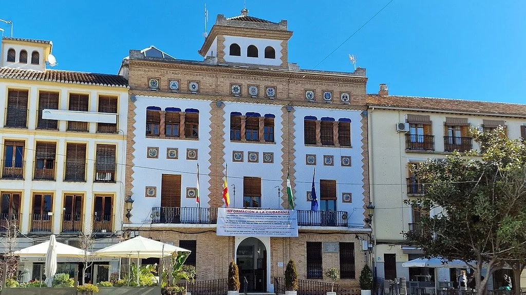
The City Hall locates stately homes, including the Casa de Doña Eva and the Peace Court building, on Real Street and its surroundings. You can include its facades in the tour. Respect the current uses of each property and check if there are any authorized visits before entering.
Half moons: understanding the irrigation of La Vega
The tourist portal describes the crescents as hydraulic works for water distribution. It associates those of Pinos or Serafín and Sombrerico with Cubillas, and that of Búcor with Velillos.
A visit focused on water allows you to observe the relationship between river, irrigation ditches and fields. Prepare the itinerary with a map and confirm the permitted steps: the ditches are part of a system in use and the roads can cross agricultural spaces.
Do not enter closed areas or manipulate gates. Keep distance from edges, waterfalls and channels, especially after rain. The existence of a heritage element does not imply that it can be reached from any shore.
Interpretation Center and Tram Park
The municipal information places the Columbian Route Interpretation Center next to the bridge and mentions archaeological pieces. It also identifies the Tram Park in the old station, with preserved rails.
Confirm opening and conditions of the center if it is an important visit for you. For the park, check the instructions for use and the condition of the areas you want to visit.
Routes through the environment and archaeological heritage
The municipal routes page presents water and archaeological proposals. It offers short durations and different modalities, but this general information is not enough to choose a route on foot: it confirms distance, gradient, start and status of the specific route.
If your interest is the sites, request information about which places have authorized access or organized visits. Do not look for pieces, do not disturb the terrain and do not touch paintings or structures. The interpretation center can be a first option to get closer to the heritage without assuming a free visit to an archaeological enclave.
Prepare a different outing from the urban walk: bring water, appropriate footwear and sun protection, and check the weather forecast. Choose the modality that the itinerary admits; A general promotion for bicycle, car or horse does not authorize riding on all tracks.
How to get there from Granada
The municipal arrival form describes the access via the N-432 towards Córdoba. Calculate the route from your origin and check incidents before leaving. When parking, follow the signs and leave clear passages and access to homes and businesses.
The Transport Consortium identifies the 0225 Granada–Pinos Puente and the 0226 Granada–Pinos Puente–Zujaira. Their queries publish schedules from September 14, 2026 to June 30, 2027. Check the “Pinos Puente” column, the direction of travel and the type of day; 226 continues towards Casanueva and Zujaira.
Also check the stops and notices before the trip: the round trip lists include different points. Both sheets identify the operator as Bus Metropolitano de Granada and indicate that the lines are not adapted to people with reduced mobility. If you need adapted transportation, check the options before organizing your visit; The Consortium publishes the telephone number 958 575 001.
How to Get to Pinos Puente from Granada, Public Transport & Where to Stay
A proposal to organize the visit
Start at the bridge and continue towards Calle Real and the church. Add the interpretation center if you have confirmed its opening. To expand, choose between the park or a water itinerary with a prepared route; There is no single duration offered to add up all the stops.
Check opening, menu, price and dietary needs with the establishment where you want to eat. If you are going to walk outside the urban center, prepare your supplies and return beforehand.
The municipal tourist directory publishes the City Council telephone number, 958 450 136, and the addresses Calle Briones, 2, and Calle Real, 123. Confirm the office you should contact when consulting heritage, visits or access.
Sources
- Pinos Puente Town Hall — location, bridges and Calle Real: https://pinos-puente.org/ciudad/pinos-puente/
- Pinos Puente municipal tourism — monuments, crescents and centers: https://www.pinospuenteturismo.es/planificar-tu-viaje/monumentos-y-lugares-de-interes/
- Pinos Puente municipal tourism — water and archaeological routes: https://www.pinospuenteturismo.es/planificar-tu-viaje/rutas/
- Pinos Puente municipal tourism — arrival by road and transportation: https://www.pinospuenteturismo.es/planificar-tu-viaje/como-llegar/
- Granada Transport Consortium — lines directory: https://siu.ctagr.es/es/lineas.php
- Municipal tourism of Pinos Puente — contacts and addresses: https://www.pinospuenteturismo.es/planificar-tu-viaje/contactos-de-interes/
- Transportation Consortium — line 225: schedules, stops and accessibility: https://siu.ctagr.es/es/horarios_lineas_tabla.php?linea=991
- Transportation Consortium — line 226: schedules, stops and accessibility: https://siu.ctagr.es/es/horarios_lineas_tabla.php?linea=992
Hiking Trail & Village Day-Trip Calculator (Time & Budget)
Calculate real hiking duration, transport cost from Granada city and local meal budget:
Guided Tours, Free Walking Tours & Tickets in Granada
Book official guided tours, monument tickets, and day trips in Granada with instant confirmation and free cancellation.
Hotels & Stays in Granada
Check live availability, location map, and stays with free cancellation in Granada.